|
Workshops
& Special Sessions
Monday, July 28, 2008
ATLSS Ecological Models: What They
Are and How to Use Them
PART I: 9:30am–12noon
PART II: 1:20pm–5:20pm
NOTE: There is no fee
to participate in this workshop. Space is limited
and seats will be filled on a first-come,
first-served basis.
Workshop Aims and Description:
 The
goal of the Across Trophic Level Systems Simulation
(ATLSS) Program has been to produce models capable
of projecting and comparing the effects of
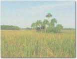
alternative hydrologic scenarios on various trophic
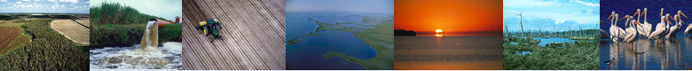
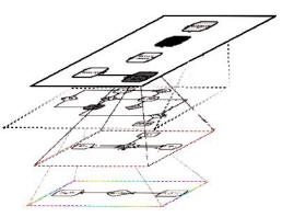
components of the Everglades. The methodology
involves: 1) a landscape structure; 2) a high
resolution topography to estimate high resolution
water depth across the landscape; 3) models to
calculate spatially explicit species indices (SESI)
for breeding and foraging success measures across
the landscape; 4) spatially explicit
individual-based (SEIB) computer simulation models
of selected species populations; 5) a variety of
visualization and evaluation tools to aid model
development, validation, and comparison to field
data, and 6) developing an efficient way for
agencies in South Florida to use models. Included in
this are numerous sub-projects for different
species, vegetation succession, analysis of
alternative approaches to developing high
resolution, models which deal with estuarine
systems, methods to allow users from a variety of
agencies to access and run the models, and methods
to enhance the computational efficiency of the
simulations. The continuing general objective is to
provide a flexible, efficient collection of methods,
utilizing the best current science, to evaluate the
relative impacts of alternative hydrologic plans on
the biotic systems of South Florida. This is done in
a spatially-explicit manner which allows different
partners to evaluate the impacts based upon
their own criteria for the locations and biotic
systems under consideration. The
goal of the Across Trophic Level Systems Simulation
(ATLSS) Program has been to produce models capable
of projecting and comparing the effects of
alternative hydrologic scenarios on various trophic
components of the Everglades. The methodology
involves: 1) a landscape structure; 2) a high
resolution topography to estimate high resolution
water depth across the landscape; 3) models to
calculate spatially explicit species indices (SESI)
for breeding and foraging success measures across
the landscape; 4) spatially explicit
individual-based (SEIB) computer simulation models
of selected species populations; 5) a variety of
visualization and evaluation tools to aid model
development, validation, and comparison to field
data, and 6) developing an efficient way for
agencies in South Florida to use models. Included in
this are numerous sub-projects for different
species, vegetation succession, analysis of
alternative approaches to developing high
resolution, models which deal with estuarine
systems, methods to allow users from a variety of
agencies to access and run the models, and methods
to enhance the computational efficiency of the
simulations. The continuing general objective is to
provide a flexible, efficient collection of methods,
utilizing the best current science, to evaluate the
relative impacts of alternative hydrologic plans on
the biotic systems of South Florida. This is done in
a spatially-explicit manner which allows different
partners to evaluate the impacts based upon
their own criteria for the locations and biotic
systems under consideration.
PART
I:
(9:30am-12noon)
 PART
I of this Workshop brings attendees up-to-date
on the ATLSS models available and what they do. This
workshop will be of interest to a large number of
government agency staff and others involved in the
evaluation of CERP plans. Each of several models
will be briefly described: PART
I of this Workshop brings attendees up-to-date
on the ATLSS models available and what they do. This
workshop will be of interest to a large number of
government agency staff and others involved in the
evaluation of CERP plans. Each of several models
will be briefly described:
-
ATLSS Hydrology
-
Spatially Explicit Species Index models
-
Fish models (GEFISH and ALFISHES)
-
Snail kite model (EVERKITE)
- Vegetation Succession and
Fire modeling
PART
II:
(1:20pm-5:20pm)
 PART
II entails a short training course in the use of
the ATLSS Data Viewer. This workshop will be of
interest to a smaller number of agency staff members
who are responsible for producing and evaluating
model output relevant to these evaluations. PART
II entails a short training course in the use of
the ATLSS Data Viewer. This workshop will be of
interest to a smaller number of agency staff members
who are responsible for producing and evaluating
model output relevant to these evaluations.
NOTE: Participants must
bring their own laptop that already has ArcGIS9.2
(service pack 4) and Spatial Analyst loaded.
Qualifications of Workshop Organizers:
Dr. Donald DeAngelis is an ecological modeler
with USGS, and coordinator of the ATLSS Program.
Steve Hartley is a USGS expert on GIS and is
the developer of the ATLSS Data Viewer.
For
more information, contact:
Donald L.
DeAngelis, USGS (Primary Contact),
Department of Biology, University of Miami, P.
O. Box 249118, Coral Gables, Florida 33124;
Phone: 305-284-1690 Fax: 305-284-3039 ; E-mail:
don_deangelis@usgs.gov
Steve Hartley, USGS, National Wetland Research
Center, 700 Cajundome Blvd., Lafayette,
Louisiana 70506; Phone: 337-266-8543 Fax:
337-266-8616 ; E-mail:
steve_hartley@usgs.gov |