Twitter    Facebook     Mail List Sign Up
CEER

Optional Field Trips

      INDEX

Click here to print one PDF of all field trip fliers.  Individual fliers may be accessed through the PDF links below.

CEER 2014 Field Trip: Hurricane Buffers: Going…Going…Gone?

                                                                                                           - Detailed Field Trip Information (PDF)

Hurricane Katrina flooded the New Orleans metropolitan area because of the failure of man-made levees and flood walls. But, it was the degradation of the natural ecosystem buffer that allowed so much storm surge to reach the city. The deadly waters came through Lake Borgne into the city directly, or by overwhelming the Orleans Landbridge separating Lake Borgne and Lake Pontchartrain and then into the city. We’ll see some of the natural and unnatural means Louisiana is using to save itself from future storms.


LOCATION: 
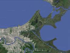
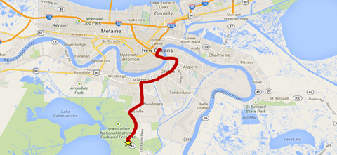
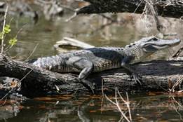
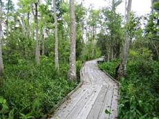
Bayou Sauvage National Wildlife Refuge, the Orleans Landbridge & Lake Borgne
ROUTE: 
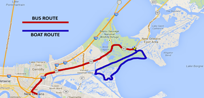
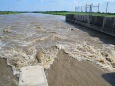
Travel by bus to Bayou Sauvage Refuge, board boats at Chef Menteur Pass, travel into Lake Borgne to survey the north shore, travel to Inner Harbor Navigation Surge Barrier, back to Chef Menteur Pass, bus back to hotel.
ROUTE LENGTH: 68 miles (48 miles round trip by bus, plus 20 miles boat tour)
DEPART/RETURN: Depart hotel at 8:00 a.m.  –  Arrive back at hotel at 12:30 p.m.
TRAVEL TIME TO SITE: 1 hour & 30 minutes (45 minutes each way)
TIME ON SITE: 3 hours
TOTAL TRIP TIME: 4 hours, 30 minutes
FIELD TRIP CAPTAIN: Chuck Perrodin, CPRA
SITE GUIDE: Chuck Perrodin, CPRA
OTHER Field Trip Captain supplies water and ice, handouts
MAXIMUM ATTENDANCE: 50 PEOPLE
DEADLINE TO REGISTER: June 15 or until Trip is Full
COST TO PARTICIPATE: $50.00


Return to top

CEER 2014 Field Trip: Diversionary Tactics–Reconnecting the river to the land

                                                                                                           - Detailed Field Trip Information (PDF)

Louisiana used to grow at a steady rate. Today it should be 60 square miles bigger than it was in 1930, but instead is 1,900 square miles smaller. Why?  Because federal levees have completely walled off the Mississippi River and for the past 80 years Louisiana land has compacted and subsided—sunk—while waiting for new replenishing sediment that never comes. But Louisiana has a plan to mimic Mother Nature by reconnecting the Mississippi to the marsh. You can see for yourself what we’re talking about during this field trip to the Bonnet Carre and Davis Pond river diversion structures.


LOCATION: Bonnet Carre spillway and Davis Pond, both upriver from New Orleans
ROUTE: Travel by bus over the spillway, to the Bonnet Carre diversion structure, across the river to the Davis Pond diversion structure and then bus back to hotel.
ROUTE LENGTH: 80 miles, all by bus
DEPART/RETURN: Depart hotel at 8:30 a.m. – Arrive back at hotel at 11:30 a.m.
TRAVEL TIME TO SITES: 2 hours (:50 to Bonnet Carre, :20 to Davis Pond, :50 back to hotel)
TIME ON SITE: 50 minutes (25 minutes at each location)
TOTAL TRIP TIME: 2 hours & 50 minutes
FIELD TRIP CAPTAIN: Chuck Villarrubia, CPRA
SITE GUIDE: Chuck Villarrubia, CPRA
OTHER Field Trip Captain supplies water and ice, handouts
MAXIMUM ATTENDANCE: 50 PEOPLE
DEADLINE TO REGISTER: June 15 or until Trip is Full
COST TO PARTICIPATE: $50.00

 http://graphics8.nytimes.com/images/2011/05/10/us/10flood_cnd/10flood_cnd-articleLarge.jpg    Return to top

CEER 2014 Field Trip: Lafitte Swamp Tour

                                                                                                           - Detailed Field Trip Information (PDF)

Want to experience Louisiana’s unique swamp environment without getting your feet wet?  Then this is the field trip for you.  You’ll be up close and personal with the flora and fauna of the Barataria Preserve of the Jean Lafitte National Historical Park and Preserve directly south of New Orleans—and yes, this is where the famed buccaneer Jean Lafitte headquartered some of his most nefarious enterprises. You’ll get a guided tour over boardwalk and dirt trails that wind through the preserve and get a taste of Louisiana’s wild wetlands with 20,000 acres of bayous, swamps, marshes, forests, alligators, and more than 300 species of birds.


LOCATION: Jean Lafitte National Historical Park and Preserve
ROUTE: Cross Crescent City Connection, West Bank Expressway to Hwy 45 to Park
ROUTE LENGTH: 16 miles (hotel to Park)
DEPART/RETURN: Depart hotel at 9 a.m. – Arrive back at hotel at Noon
TRAVEL TIME TO SITE: 1 hour (30 minutes each way)
TIME ON SITE: 2 hours
TOTAL TRIP TIME: 3 hours
FIELD TRIP CAPTAIN: TBD
SITE GUIDE: Park Service to provide an on-site guide
OTHER Field Trip Captain supplies water and ice, handouts
MAXIMUM ATTENDANCE: 50 PEOPLE
DEADLINE TO REGISTER: June 15 or until Trip is Full
COST TO PARTICIPATE: $50.00

http://www.vacationhomes.net/blog/pub/1336032454_Jean-Lafitte-National-Historical-Park-and-Preserve.jpg  http://media-cdn.tripadvisor.com/media/photo-s/01/a1/6a/2e/jean-lafitte-national.jpg  http://www.adventure-crew.com/wp-content/uploads/2009/06/jeanlaf.jpgReturn to top


Thank you to our sponsors!

Host Organizations

NCER


SER

Post Conference Information

Program Book (PDF)

Abstract Book (PDF)

Speaker Presentations

Poster Presentations

Conference Photo Albums


Experience NOLA

UF IFAS

SER Membership Ad

Home | Questions | UF/IFAS Office of Conferences and Institutes
This page is designed and maintained by the UF/IFAS/OCI Graphics Editor and Webmaster.